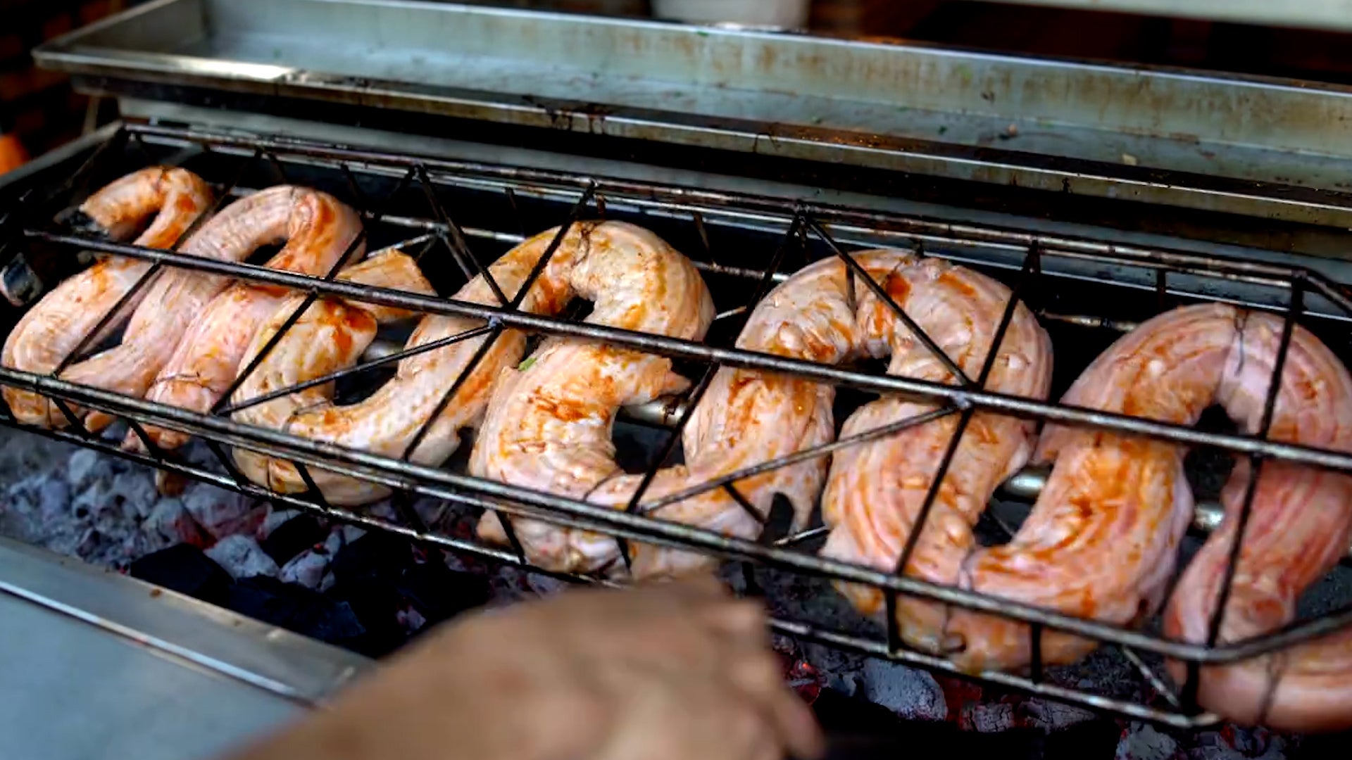
Recent Cities
Tallinn, Estonia
Hurghada, Egypt
Eelde, Netherlands
Bursa, Turkey
Phoenix, AZ
Chattanooga, TN
Tel Aviv, Israel
Sioux City, IA
Punta Cana, Dominican Republic
Reus, Spain
NC State Area, Raleigh, North Carolina (PWS)
Updated: 9:49 PM EST on February 09, 2010
38.2 °F
Overcast
Windchill:
38 °F
Humidity:
94%
Dew Point:
37 °F
Wind:
Calm
Wind Gust:
13.0 mph
Pressure:
29.60 in
(Falling)
Visibility:
5.0 miles
UV:
0 out of 16
Clouds:
Mostly Cloudy
600 ft
Overcast
1200 ft
(Above Ground Level)
Elevation:
350 ft
» Weather History for This Location
Select a source for your current conditions:
Raleigh-Durham Airport, NC (KRDU)
Smithfield, NC (KJNX)
Louisburg, NC (KLHZ)
Chapel Hill, NC (KIGX)
NC State Area
HADS MARSH CREEK AT HWY 401 AT NEW HO NC US
SW Raleigh-Nuttree Place
North Hills Mall (Spring Valley)
Wake Med Raleigh
Hedingham
APRSWXNET Garner NC US
Winchester - NE Raleigh
Swiftbrook Cir.
Millbrook High School
Northwyck Place
Garner, NC
Lake Wheeler
Will-O-Dean Acres
North-West Raleigh
Wessex
North Raleigh - Durant Trace
Silverton Subdivision
Crest of Carolina
N Raleigh-Durant & Falls
Rock It Learning Science & Technology Camp
Mt. Roundtree
Meryton
Henley Subdivision
Village at Westgate
North Raleigh (Falls Lake)
Back Yard on 10th fairway of Crooked Creek Golf Course.
Providence Commons
MacArthur Park
Wood Valley
Preston Forest
History & Almanac
Max Temperature:
Min Temperature:
Normal (KRDU)
53 °F
31 °F
Record (KRDU)
74 °F
(1994)
11 °F
(1977)
Yesterday
46 °F
22 °F
Yesterday's Heating Degree Days: 31
Detailed History and Climate (KRDU)
Today's State Extremes
Astronomy
February 9, 2010
Rise:
Set:
Actual Time
7:07 AM EST
5:50 PM EST
Civil Twilight
6:41 AM EST
6:16 PM EST
Nautical Twilight
6:11 AM EST
6:46 PM EST
Astronomical Twilight
5:41 AM EST
7:16 PM EST
Moon
4:14 AM EST (2/9)
1:54 PM EST (2/9)
Length Of Visible Light:
11h 35m
Length of Day
10h 42m
Tomorrow will be 2m 0s longer .
Extended View
Waning Crescent, 14% of the Moon is Illuminated
Today
Feb 13
New
Feb 21
First Quarter
Feb 28
Full
Mar 7
Last Quarter
For more information about the solar system:
Raleigh-Durham News
Free Weather Stickers® for Your Homepage!
Wednesday
Thursday
Friday
Saturday
Sunday
36° F
|
25° F
43° F
|
23° F
43° F
|
27° F
43° F
|
23° F
45° F
|
27° F
Partly Cloudy
Partly Cloudy
Partly Cloudy
Partly Cloudy
Partly Cloudy
Forecast for Wake
Updated: 3:54 PM EST on February 9, 2010
High Wind Warning in effect from 6 am to 9 PM EST Wednesday...
Tonight
Cloudy with rain likely with patchy drizzle this evening...then partly cloudy after midnight. Breezy and cold with lows in the lower 30s. North winds around 5 mph...increasing to west 15 to 20 mph after midnight. Chance of rain 60 percent.
Wednesday
Partly sunny and windy. Highs in the upper 30s. West winds around 20 mph...increasing to 25 to 30 mph in the afternoon. Gusts up to 50 to 55 mph.
Wednesday Night
Mostly clear and windy. Cold with lows in the mid 20s. West winds 15 to 25 mph.
Thursday
Mostly sunny and breezy. Highs in the lower 40s. Northwest winds 15 to 20 mph with gusts up to 30 mph.
Thursday Night
Mostly clear. Cold with lows in the mid 20s. Northwest winds around 10 mph.
Friday through Saturday
Partly cloudy. Highs in the lower 40s. Lows in the upper 20s.
Saturday Night
Mostly clear. Cold with lows in the mid 20s.
Sunday through Presidents Day
Partly cloudy. Highs in the mid 40s. Lows in the upper 20s.
Monday Night and Tuesday
Mostly clear. Lows in the lower 20s. Highs in the mid 40s.
Alternate Computer Forecast: AVN MOS Weather Graph
Air quality Forecast for Raleigh-Durham-Chapel Hill
Sports Weather
MLB:
Date:
Forecast:
Yankees vs. Red Sox
8:05 PM EDT on April 04, 2010
Average High 52° F/ 11° C
Phillies vs. Nationals
1:05 PM EDT on April 05, 2010
Average High 61° F/ 16° C
Football (Soccer):
Date:
Forecast:
Brest vs. Toulouse
6:00 PM CET on February 10, 2010
Chance of Snow, High 32° F/ 0° C
SpVgg Greuther Furth vs. Bayern München
7:00 PM CET on February 10, 2010
Chance of Snow, High 28° F/ -2° C
NASCAR:
Date:
Forecast:
Gatorade Duel 1
2:15 PM EST on February 11, 2010
Partly Cloudy,
54 °F
Gatorade Duel 2
4:00 PM EST on February 11, 2010
Partly Cloudy,
56 °F
Blogs in This Area
City:
Member:
Title:
Last Activity:
There are no recent blogs in this area. Why not create your own ?
Weather Stations
Station Location
Temp.
Dew Point
Humidity
Wind
Pressure
Precipitation
Windchill
Elevation
Updated
Type
NC State Area, Raleigh, NC
38.2 °F
37 °F
94%
29.60 in
0.00 in
/ hr
38 °F
350 ft
9:49 PM EST
Rapid Fire
Website
HADS MARSH CREEK AT HWY 401 AT NEW HO NC, Raleigh, NC
°F
-
-
-
0.00 in
/ hr
-
198 ft
6:15 PM EST
MADIS
Website
SW Raleigh-Nuttree Place, Raleigh, NC
37.8 °F
36 °F
92%
29.77 in
0.00 in
/ hr
38 °F
374 ft
6:42 PM EST
Normal
North Hills Mall (Spring Valley), Raleigh, NC
36.6 °F
35 °F
94%
29.51 in
0.00 in
/ hr
37 °F
286 ft
9:40 PM EST
Normal
Wake Med Raleigh, Raleigh, NC
37.6 °F
37 °F
98%
29.38 in
0.00 in
/ hr
38 °F
223 ft
9:49 PM EST
Rapid Fire
Hedingham, Raleigh, NC
37.2 °F
36 °F
95%
29.69 in
0.02 in
/ hr
33 °F
222 ft
9:49 PM EST
Rapid Fire
APRSWXNET Garner NC , Garner, NC
37 °F
36 °F
95%
29.72 in
0.00 in
/ hr
37 °F
330 ft
9:32 PM EST
MADIS
Website
Winchester - NE Raleigh, Raleigh, NC
37.0 °F
35 °F
93%
29.66 in
0.00 in
/ hr
37 °F
280 ft
9:48 PM EST
Normal
Website
Swiftbrook Cir., Raleigh, NC
37.2 °F
31 °F
77%
29.20 in
0.00 in
/ hr
37 °F
406 ft
9:49 PM EST
Rapid Fire
Website
Millbrook High School, Raleigh, NC
36.8 °F
35 °F
93%
29.64 in
0.00 in
/ hr
37 °F
380 ft
9:49 PM EST
Rapid Fire
Northwyck Place, Raleigh, NC
36.7 °F
36 °F
96%
29.69 in
0.00 in
/ hr
37 °F
404 ft
9:45 PM EST
Normal
Website
Garner, NC, Garner, NC
37.1 °F
36 °F
95%
29.72 in
-
/ hr
37 °F
330 ft
9:47 PM EST
Normal
Lake Wheeler, Raleigh, NC
38.1 °F
34 °F
88%
29.38 in
0.00 in
/ hr
38 °F
380 ft
9:45 PM EST
Normal
Website
Will-O-Dean Acres, Raleigh, NC
36.5 °F
36 °F
100%
29.56 in
0.00 in
/ hr
36 °F
301 ft
9:41 PM EST
Normal
Website
North-West Raleigh, Raleigh, NC
36.3 °F
34 °F
92%
29.76 in
0.00 in
/ hr
36 °F
466 ft
9:45 PM EST
Normal
Wessex, Cary, NC
37.3 °F
36 °F
96%
29.61 in
0.01 in
/ hr
37 °F
335 ft
9:32 PM EST
Normal
North Raleigh - Durant Trace, Raleigh, NC
37.4 °F
36 °F
96%
29.67 in
0.00 in
/ hr
37 °F
372 ft
9:49 PM EST
Rapid Fire
Website
Silverton Subdivision, Cary, NC
37.0 °F
36 °F
96%
29.68 in
0.05 in
/ hr
37 °F
390 ft
9:49 PM EST
Rapid Fire
Crest of Carolina, Raleigh, NC
37.6 °F
37 °F
98%
29.72 in
0.00 in
/ hr
38 °F
360 ft
9:40 PM EST
Normal
Website
N Raleigh-Durant & Falls, Raleigh, NC
36.0 °F
36 °F
99%
29.62 in
0.00 in
/ hr
36 °F
423 ft
9:49 PM EST
Rapid Fire
Rock It Learning Science & Technology Ca, Raleigh, NC
36.3 °F
36 °F
97%
29.68 in
0.00 in
/ hr
36 °F
376 ft
9:30 PM EST
Normal
Website
Mt. Roundtree, Cary, NC
39.9 °F
36 °F
87%
29.74 in
0.02 in
/ hr
40 °F
420 ft
9:49 PM EST
Rapid Fire
Website
Meryton, Raleigh, NC
37.0 °F
35 °F
94%
29.58 in
0.00 in
/ hr
37 °F
217 ft
9:49 PM EST
Normal
Website
Henley Subdivision, Raleigh, NC
36.2 °F
36 °F
100%
29.63 in
0.00 in
/ hr
36 °F
465 ft
9:49 PM EST
Rapid Fire
Website
Village at Westgate, Raleigh, NC
36.7 °F
33 °F
87%
29.07 in
0.00 in
/ hr
37 °F
468 ft
9:49 PM EST
Rapid Fire
North Raleigh (Falls Lake), Raleigh, NC
37.0 °F
37 °F
100%
29.85 in
0.00 in
/ hr
37 °F
300 ft
9:45 PM EST
Normal
Back Yard on 10th fairway of Crooked Cre, Fuquay Varina, NC
37.5 °F
36 °F
96%
29.65 in
0.01 in
/ hr
38 °F
392 ft
9:45 PM EST
Normal
Providence Commons, Cary, NC
37.6 °F
37 °F
97%
29.63 in
0.00 in
/ hr
38 °F
430 ft
9:49 PM EST
Rapid Fire
MacArthur Park, Cary, NC
37.7 °F
34 °F
87%
29.08 in
0.00 in
/ hr
38 °F
480 ft
9:47 PM EST
Normal
Website
Wood Valley, Raleigh, NC
36.7 °F
35 °F
94%
29.65 in
0.00 in
/ hr
37 °F
427 ft
9:49 PM EST
Rapid Fire
Preston Forest, Cary, NC
38.5 °F
38 °F
98%
29.73 in
-
/ hr
38 °F
346 ft
9:49 PM EST
Rapid Fire
Would you like to share your weather data with the rest of the world?
Add Your Weather Station!
Warnings and Notices
High Wind Warning
Statement as of 5:50 PM EST on February 09, 2010
... High Wind Warning remains in effect from 6 am to 9 PM EST
Wednesday...
Very strong westerly winds will develop across the area Wednesday
morning... then gradually diminish Wednesday evening into
Wednesday night. Wind speeds will peak during the late morning
and afternoon hours... when sustained winds of 25 to 35 mph and
damaging gusts of 45 to 55 mph are expected. A few locations
across the northern Piedmont and northern coastal plain may see
wind gusts up to 60 mph.
Recent widespread precipitation events have resulted in soggy
ground conditions across central North Carolina. The combination
of weak root support and strong gusty winds will result in the
Downing of numerous trees and power lines. Minor property damage
such as ripped siding or shingles may also occur.
Precautionary/preparedness actions...
A High Wind Warning means a hazardous high wind event is expected
or occurring. Be prepared for numerous downed trees and power
lines. Do not cross wires as they may still be live.
Additionally... strong winds will make handling of high profile
vehicles very difficult. Those driving high profile vehicles
should use extra caution... especially in open areas such as on
bridges and overpasses.
Copyright © 2010 Weather Underground, Inc.