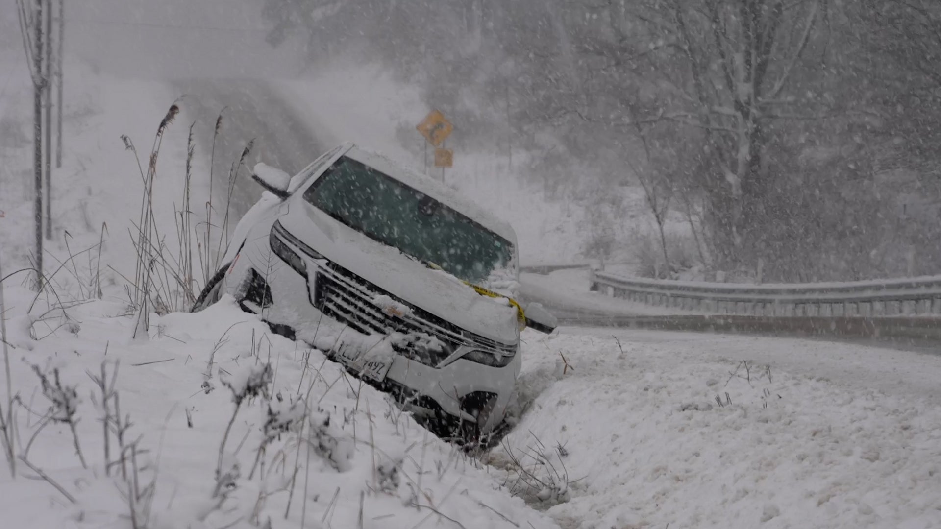
Albuquerque, NM

2:36 AM MDT on May 23, 2012 (GMT -0600)
Elev: 4997 ft
Lon: 106.6° W
Lat: 35.2° N
Source
Rapid Fire Updates™
Updated 2:35 AM MDT Get Free Weather Stickers® Share:
Your Custom Weather Sticker®

Copy the following lines of HTML:
Tropical Weather: Invest 94 (North Atlantic) Tropical Storm Bud (East Pacific) Tropical Storm Sanvu (Western Pacific)
Weather Summary
Weather Underground Forecast for Wednesday, May 23, 2012.

The Nation will continue to see relatively stagnant weather on Wednesday as afternoon thunderstorms develop in the East and the Northwest continues to see cool, wet weather.

The Northeast will see another day of afternoon showers and thunderstorms as the disorganized frontal boundaries that have been lingering around for the last few days continue their snails pace drift eastward. Thunderstorms are anticipated from the Carolinas through coastal Maine, with the bulk of precipitation expected in the southern Appalachians.

Further south, wet weather should end on Wednesday, with clear skies building into the Gulf Coast states.

Clear skies are also anticipated throughout the Plains, but the Northern Plains will see cloud cover move in as some rain approaches from the West. The precipitation will be most pronounced over the Dakotas in the morning, then into Minnesota by afternoon.

Further west Precipitation will increase a bit in coverage as moisture streams into the Northwest. Most of Washington, Oregon and Idaho will see Precipitation on Wednesday.

The nation’s biggest weather shift will come to Florida, where heavy rain will move into southern portions of the state as moisture associated with the remains of Tropical Storm Alberto rain themselves out across the western Atlantic.

Albuquerque Weather at a Glance

Updated 2:35 AM MDT
Elevation
4999 ft
Report Station
You are about to report this weather station for bad data.

Please select the information which is incorrect and click 'Submit' otherwise click 'Cancel'.

Cancel

Now
Clear
Clear
Temperature
60.2 °F
Feels Like 60.2 °F
Wind(mph)
0.0
Sunrise / Set
5:56 AM
8:10 PM
Moon
Waxing Crescent
Tonight
Partly Cloudy 54 °F
Partly Cloudy
Wednesday
Clear 97 °F
Clear
Wednesday Night
Clear 57 °F
Clear
Thursday
Clear 91 | 57 °F
Clear
Friday
Clear 91 | 57 °F
Clear
Saturday
Clear 91 | 52 °F
Clear
Today is forecast to be nearly the same temperature as yesterday.
Conditions
Pressure
29.60 in
Visibility
10.0 miles
Clouds
Clear -
Moisture
Humidity
29%
Rainfall
0.00 in
Snow Depth
Not available.
METAR
METAR KABQ 230752Z 13009KT 10SM CLR 21/M10 A2988 RMK AO2 SLP023 T02061100
Don't speak METAR? Read our FAQ.
Weather Radio
Temperature
Temperature
60.2 °F
Dew Point
28 °F
Wind
Speed / Dir
Calm
Wind Gust
1.0 mph
Health
UV
0 out of 16
Pollen
6.40 out of 12
Pollen Forecast
Air Quality
Not available.
Flu Activity
Sporadic
View Flu Map
Loading…
Source: BestForecast
Descriptive Forecast
Wednesday
clear Clear. High of 97F. Windy. Winds from the WSW at 15 to 40 mph with gusts to 50 mph.
Wednesday Night
nt_clear Clear. Low of 57F. Windy. Winds from the WSW at 15 to 40 mph with gusts to 50 mph.
Thursday
clear Clear. High of 91F. Windy. Winds from the WSW at 15 to 30 mph with gusts to 40 mph.
Thursday Night
nt_clear Clear. Low of 57F. Windy. Winds from the WSW at 10 to 30 mph with gusts to 40 mph.
Friday
clear Clear. High of 91F. Windy. Winds from the SSW at 10 to 25 mph with gusts to 35 mph.
Friday Night
nt_clear Clear. Low of 57F. Breezy. Winds from the South at 10 to 30 mph.
Saturday
clear Clear. High of 91F. Breezy. Winds from the South at 15 to 30 mph.
Saturday Night
nt_clear Clear. Low of 52F. Breezy. Winds from the SW at 10 to 30 mph shifting to the WNW after midnight.
Sunday
clear Clear. High of 90F. Winds from the West at 5 to 15 mph.
Sunday Night
nt_clear Clear. Low of 50F. Winds from the NNW at 5 to 20 mph.
Monday
clear Clear. High of 90F. Winds from the NE at 5 to 10 mph shifting to the SW in the afternoon.
Monday Night
nt_clear Clear. Low of 48F. Winds less than 5 mph.
Tuesday
clear Clear. High of 91F. Winds from the West at 5 to 10 mph.
Tuesday Night
nt_clear Clear. Low of 50F. Winds from the WNW at 5 to 15 mph.
Wednesday
clear Clear. High of 91F. Winds from the WNW at 5 to 10 mph.
Wednesday Night
nt_clear Clear. Low of 54F. Winds from the WNW at 5 to 15 mph.
Thursday
partlycloudy Partly cloudy. High of 90F. Winds less than 5 mph.
Thursday Night
nt_partlycloudy Partly cloudy. Low of 54F. Winds from the WNW at 5 to 10 mph.
Friday
partlycloudy Partly cloudy. High of 90F. Winds less than 5 mph.
Friday Night
nt_clear Partly cloudy. Low of 54F. Winds less than 5 mph.
Saturday
partlycloudy Clear. High of 91F. Winds from the WSW at 5 to 10 mph.
Saturday Night
nt_clear Clear. Low of 54F. Winds from the WSW at 5 to 10 mph.
Loading…
 
First Previous Last Next  
Updated:  


Nowcast
High wind watch in effect from Wednesday morning through Wednesday evening...

Forecast

View Calendar 10-Day Forecast for station KNMALBUQ52

Wednesday, 23
Clear
97 | 57 °F
Clear
Chance of
Precipitation
0%
Thursday, 24
Clear
91 | 57 °F
Clear
Chance of
Precipitation
0%
Friday, 25
Clear
91 | 57 °F
Clear
Chance of
Precipitation
0%
Saturday, 26
Clear
91 | 52 °F
Clear
Chance of
Precipitation
0%
Sunday, 27
Clear
90 | 50 °F
Clear
Chance of
Precipitation
0%
Monday, 28
Clear
90 | 48 °F
Clear
Chance of
Precipitation
0%
Tuesday, 29
Clear
91 | 50 °F
Clear
Chance of
Precipitation
0%
Wednesday, 30
Clear
91 | 54 °F
Clear
Chance of
Precipitation
0%
Thursday, 31
Partly Cloudy
90 | 54 °F
Partly Cloudy
Chance of
Precipitation
0%
Friday, 1
Partly Cloudy
90 | 54 °F
Partly Cloudy
Chance of
Precipitation
0%
Source: BestForecast at 1:39 AM MDT on May 23, 2012
Descriptive Forecast
Wednesday
clear Clear. High of 97F. Windy. Winds from the WSW at 15 to 40 mph with gusts to 50 mph.
Wednesday Night
nt_clear Clear. Low of 57F. Windy. Winds from the WSW at 15 to 40 mph with gusts to 50 mph.
Hourly Forecast 6AM 12 Noon 6PM 12 Midnight
Temp. | Dew Point 54 | 14 91 | 14 90 | 21 70 | 23
Wind 7 mph WSW 22 mph WSW 37 mph West 15 mph WSW
Humidity 19% 5% 8% 17%
Chance of Precip. 0% 0% 0% 0%
Cloud Cover 8% 8% 3% 3%
Conditions Clear Clear Clear Clear
Sunrise & Sunset
5:56 AM
8:10 PM
The quality of the forecasted high temperature for this day is good. MaxT RMSE [2.30], Average RMSE [2.30]
The National Weather Service forecast quality is fair. MaxT RMSE [3.25], Average RMSE [2.50] : Use NWS
Source: BestForecast at 1:39 AM MDT on May 23, 2012
Descriptive Forecast
Thursday
clear Clear. High of 91F. Windy. Winds from the WSW at 15 to 30 mph with gusts to 40 mph.
Thursday Night
nt_clear Clear. Low of 57F. Windy. Winds from the WSW at 10 to 30 mph with gusts to 40 mph.
Hourly Forecast 6AM 12 Noon 6PM 12 Midnight
Temp. | Dew Point 59 | 37 84 | 36 88 | 32 66 | 19
Wind 14 mph WSW 21 mph SW 29 mph WSW 11 mph WSW
Humidity 42% 16% 13% 16%
Chance of Precip. 0% 0% 0% 0%
Cloud Cover 9% 9% 6% 6%
Conditions Clear Clear Clear Clear
Sunrise & Sunset
5:56 AM
8:10 PM
The quality of the forecasted high temperature for this day is fair. MaxT RMSE [2.74], Average RMSE [2.27]
The National Weather Service forecast quality is fair. MaxT RMSE [3.39], Average RMSE [2.47] : Use NWS
Source: BestForecast at 1:39 AM MDT on May 23, 2012
Descriptive Forecast
Friday
clear Clear. High of 91F. Windy. Winds from the SSW at 10 to 25 mph with gusts to 35 mph.
Friday Night
nt_clear Clear. Low of 57F. Breezy. Winds from the South at 10 to 30 mph.
Hourly Forecast 6AM 12 Noon 6PM 12 Midnight
Temp. | Dew Point 57 | 41 81 | 32 88 | 32 66 | 18
Wind 5 mph SSW 17 mph SSW 29 mph WSW 11 mph South
Humidity 53% 16% 13% 15%
Chance of Precip. 0% 0% 0% 0%
Cloud Cover 16% 16% 6% 2%
Conditions Clear Clear Clear Clear
Sunrise & Sunset
5:55 AM
8:11 PM
The quality of the forecasted high temperature for this day is fair. MaxT RMSE [2.76], Average RMSE [2.86]
The National Weather Service forecast quality is poor. MaxT RMSE [3.51], Average RMSE [3.50] : Use NWS
Source: BestForecast at 1:39 AM MDT on May 23, 2012
Descriptive Forecast
Saturday
clear Clear. High of 91F. Breezy. Winds from the South at 15 to 30 mph.
Saturday Night
nt_clear Clear. Low of 52F. Breezy. Winds from the SW at 10 to 30 mph shifting to the WNW after midnight.
Hourly Forecast 6AM 12 Noon 6PM 12 Midnight
Temp. | Dew Point 57 | 36 86 | 23 84 | 12 63 | 27
Wind 10 mph SSE 23 mph SSW 29 mph SSW 10 mph West
Humidity 42% 9% 6% 24%
Chance of Precip. 0% 0% 0% 0%
Cloud Cover 0% 0% 0% 0%
Conditions Clear Clear Clear Clear
Sunrise & Sunset
5:55 AM
8:12 PM
The quality of the forecasted high temperature for this day is fair. MaxT RMSE [2.76], Average RMSE [1.74]
The National Weather Service forecast quality is poor. MaxT RMSE [3.65], Average RMSE [3.64] : Use NWS
Source: BestForecast at 1:39 AM MDT on May 23, 2012
Descriptive Forecast
Sunday
clear Clear. High of 90F. Winds from the West at 5 to 15 mph.
Sunday Night
nt_clear Clear. Low of 50F. Winds from the NNW at 5 to 20 mph.
Hourly Forecast 6AM 12 Noon 6PM 12 Midnight
Temp. | Dew Point 54 | 32 81 | 28 82 | 10 59 | 10
Wind 5 mph WNW 13 mph WSW 17 mph WNW 8 mph North
Humidity 44% 14% 6% 14%
Chance of Precip. 0% 0% 0% 0%
Cloud Cover 0% 0% 0% 0%
Conditions Clear Clear Clear Clear
Sunrise & Sunset
5:54 AM
8:12 PM
The quality of the forecasted high temperature for this day is good. MaxT RMSE [2.43], Average RMSE [2.70]
The National Weather Service forecast quality is poor. MaxT RMSE [4.07], Average RMSE [3.89] : Use NWS
Source: BestForecast at 1:39 AM MDT on May 23, 2012
Descriptive Forecast
Monday
clear Clear. High of 90F. Winds from the NE at 5 to 10 mph shifting to the SW in the afternoon.
Monday Night
nt_clear Clear. Low of 48F. Winds less than 5 mph.
Hourly Forecast 6AM 12 Noon 6PM 12 Midnight
Temp. | Dew Point 54 | 36 81 | 3 84 | 28 63 | 16
Wind 6 mph NNE 3 mph SW 3 mph SSE 3 mph ENE
Humidity 47% 5% 13% 15%
Chance of Precip. 0% 0% 0% 0%
Cloud Cover 0% 0% 0% 0%
Conditions Clear Clear Clear Clear
Sunrise & Sunset
5:54 AM
8:12 PM
The quality of the forecasted high temperature for this day is fair. MaxT RMSE [3.32], Average RMSE [3.09]
The National Weather Service forecast quality is poor. MaxT RMSE [3.80], Average RMSE [4.01] : Use NWS
Source: BestForecast at 1:39 AM MDT on May 23, 2012
Descriptive Forecast
Tuesday
clear Clear. High of 91F. Winds from the West at 5 to 10 mph.
Tuesday Night
nt_clear Clear. Low of 50F. Winds from the WNW at 5 to 15 mph.
Hourly Forecast 6AM 12 Noon 6PM 12 Midnight
Temp. | Dew Point 52 | 32 84 | 43 86 | -12 64 | 5
Wind 2 mph NW 8 mph SW 10 mph West 6 mph NW
Humidity 47% 22% 2% 9%
Chance of Precip. 0% 0% 0% 0%
Cloud Cover 0% 0% 0% 0%
Conditions Clear Clear Clear Clear
Sunrise & Sunset
5:54 AM
8:12 PM
The quality of the forecasted high temperature for this day is fair. MaxT RMSE [3.16], Average RMSE [3.22]
The National Weather Service forecast quality is poor. MaxT RMSE [3.61], Average RMSE [4.29] : Use NWS
Source: BestForecast at 1:39 AM MDT on May 23, 2012
Descriptive Forecast
Wednesday
clear Clear. High of 91F. Winds from the WNW at 5 to 10 mph.
Wednesday Night
nt_clear Clear. Low of 54F. Winds from the WNW at 5 to 15 mph.
Hourly Forecast 6AM 12 Noon 6PM 12 Midnight
Temp. | Dew Point 54 | 32 86 | 12 82 | 27 63 | 27
Wind 4 mph NNW 6 mph West 11 mph WNW 6 mph WNW
Humidity 44% 6% 12% 24%
Chance of Precip. 0% 0% 0% 10%
Cloud Cover 0% 0% 0% 3%
Conditions Clear Clear Clear Clear
Sunrise & Sunset
5:54 AM
8:12 PM
The quality of the forecasted high temperature for this day is fair. MaxT RMSE [3.06], Average RMSE [2.79]
Source: BestForecast at 1:39 AM MDT on May 23, 2012
Descriptive Forecast
Thursday
partlycloudy Partly cloudy. High of 90F. Winds less than 5 mph.
Thursday Night
nt_partlycloudy Partly cloudy. Low of 54F. Winds from the WNW at 5 to 10 mph.
Hourly Forecast 6AM 12 Noon 6PM 12 Midnight
Temp. | Dew Point 54 | 43 84 | 46 75 | 28 64 | 43
Wind 1 mph NW 3 mph WSW 7 mph West 4 mph WNW
Humidity 65% 27% 17% 46%
Chance of Precip. 10% 10% 10% 10%
Cloud Cover 7% 27% 46% 41%
Conditions Clear Partly Cloudy Partly Cloudy Partly Cloudy
Sunrise & Sunset
5:54 AM
8:12 PM
The quality of the forecasted high temperature for this day is poor. MaxT RMSE [3.92], Average RMSE [3.60]
Source: BestForecast at 1:39 AM MDT on May 23, 2012
Descriptive Forecast
Friday
partlycloudy Partly cloudy. High of 90F. Winds less than 5 mph.
Friday Night
nt_clear Partly cloudy. Low of 54F. Winds less than 5 mph.
Hourly Forecast 6AM 12 Noon 6PM 12 Midnight
Temp. | Dew Point 57 | 46 82 | 59 81 | 39 66 | 37
Wind 1 mph NW 3 mph WSW 6 mph WSW 4 mph WSW
Humidity 67% 44% 21% 35%
Chance of Precip. 10% 10% 10% 0%
Cloud Cover 36% 27% 18% 24%
Conditions Partly Cloudy Partly Cloudy Clear Clear
Sunrise & Sunset
5:54 AM
8:12 PM
Source: BestForecast at 1:39 AM MDT on May 23, 2012
Descriptive Forecast
Saturday
partlycloudy Clear. High of 91F. Winds from the WSW at 5 to 10 mph.
Saturday Night
nt_clear Clear. Low of 54F. Winds from the WSW at 5 to 10 mph.
Hourly Forecast 6AM 12 Noon 6PM 12 Midnight
Temp. | Dew Point 57 | 39 84 | 52 82 | 28 66 | 27
Wind 2 mph SW 7 mph WSW 9 mph WSW 6 mph West
Humidity 49% 31% 13% 21%
Chance of Precip. 0% 10% 10% 0%
Cloud Cover 29% 17% 5% %
Conditions Partly Cloudy Clear Clear Clear
Sunrise & Sunset
5:54 AM
8:12 PM
Nearby
History & Almanac
May 23, 2012 Max Temp Min Temp
Normal (KABQ) 82 °F 52 °F
Record (KABQ) 97 °F (2000) 36 °F (1975)
Yesterday 92 °F 65 °F
Yesterday's Cooling Degree Days: 14
Choose a date
Earthquake Activity
City Distance Mag. Time & Date
No recent earthquake activity has been reported nearby.
Minimum magnitude displayed is 2.5.
Astronomy
May. 23, 2012 Rise Set
Actual Time 5:56 AM MDT 8:10 PM MDT
Civil Twilight 5:28 AM MDT 8:39 PM MDT
Nautical Twilight 4:53 AM MDT 9:14 PM MDT
Astronomical Twilight 4:14 AM MDT 9:52 PM MDT
Moon 8:02 AM MDT 10:34 PM MDT
Length Of Visible Light 15h 10m
Length of Day
14h 13m
Tomorrow will be 1m 15s longer.
Waxing Crescent, 5% of the Moon is Illuminated
Today
Waxing Crescent
May 28
First Quarter
Jun 4
Full
Jun 11
Last Quarter
Jun 19
New
Today's Extremes
State Highs State Lows
78 °F
Socorro
75 °F
Alamogordo
74 °F
Belen
72 °F
Tucumcari
51 °F
Taos
55 °F
Raton
55 °F
Silver City
57 °F
Las Vegas
58 °F
Moriarty
Snow Depth
Station Depth Elevation
Rice Park 0 in 8460 ft
Bateman 0 in 9300 ft
Chamita 0 in 8400 ft
Sierra Blanca 3 in 10280 ft
Lookout Mountain 0 in 8500 ft
WunderPhotos®
In Progress
Hatteras Storm
Uploaded by: emixam101
1,495,064 photos uploaded!
WunderBlogs®

There are no recent blogs in this area. Why not create your own?

Travel & Activities
Travel Planning
Destination? *
When are you going?
to
Is there an activity you would like to explore?
* Required field
Nearby Events
Event Date Forecast
Albuquerque Isotopes vs. Fresno Grizzlies 6:00 PM MDT 2012-05-23 Partly Cloudy, 88°F
YGL ABQ Social Hour 5:00 PM MDT 2012-05-23 Clear, 87°F
Albuquerque Isotopes vs. Fresno Grizzlies 6:00 PM MDT 2012-05-24 Partly Cloudy, 86°F
Lecture Series -- New Mexico's Living Landscapes 7:00 PM MDT 2012-05-24 Partly Cloudy, 84°F
Event data courtesy eviesays.com
Aviation
City Temp. Conditions Updated
Albuquerque 69 °F Clear 1:52 AM MDT
Albuquerque Double Eagle 66 °F Clear 2:15 AM MDT
Moriarty This station is not reporting.
Santa Fe 65 °F Clear 12:53 AM MDT
Flight To ETA Status
UPS894
Louisville, KY
KABQ 04:20AM On Time
Flight Tracker by FlightAware FlightAware
Type Condition
Flight Rule: VFR (KABQ)
Wind Speed: 9.0 kts.
Wind Dir: 323° (NW)
Ceiling: Unlimited

METAR KABQ 230752Z 13009KT 10SM CLR 21/M10 A2988 RMK AO2 SLP023 T02061100

Sports
Event Date Forecast
Rangers vs. Mariners 7:10 PM PDT on May 22, 2012 Rain Showers, 54 °F
Red Sox vs. Orioles 12:35 PM EDT on May 23, 2012 Thunderstorm, 77 °F
Event Date Forecast
Recreativo de Huelva vs. Valladolid 12:00 PM CEST on May 23, 2012 Clear, High 75° F/ 24° C
Numancia vs. Almería 12:00 PM CEST on May 23, 2012 Clear, High 80° F/ 27° C
Event Date Forecast
Coca-Cola 600 6:16 PM EDT on May 27, 2012 Partly Cloudy, 83 °F
FedEx 400 benefiting Autism Speaks 1:15 PM EDT on June 03, 2012 Average High 79° F/ 26° C
Event Date Forecast
Crowne Plaza Invitational at Colonial 8:30 AM CDT on May 24, 2012 Clear, 70 °F
Crowne Plaza Invitational at Colonial 8:30 AM CDT on May 25, 2012 Clear, 72 °F
Weather Stations
Station Location Temp. Heat Index Dew Point Humidity Wind Precipitation Elevation Updated Type Website
Alameda and the River, Albuquerque, NM 60.2 °F - 28 °F 29% NW  at  0.0 mph 0.00 in / hr 4999 ft 2:35 AM MDT Normal  
Bosque Del Rio, Albuquerque, NM 62.7 °F - 24 °F 23% SW  at  0.0 mph - / hr 4993 ft 2:24 AM MDT Normal  
HADS NORTH FLOODWAY CHANNEL NEAR ALAM NM, Albuquerque, NM - - - - North  at  - 0.00 in / hr 5015 ft 12:20 AM MDT MADIS
Alban Hills (Winn), Albuquerque, NM 71.6 °F 73 °F 16 °F 12% ENE  at  0.9 mph 0.00 in / hr 5200 ft 2:36 AM MDT Rapid Fire
Balloon Fiesta, Albuquerque, NM 72.0 °F 74 °F 23 °F 16% East  at  2.0 mph 0.00 in / hr 5085 ft 2:33 AM MDT Normal
Vista del Norte, Albuquerque, NM 71.5 °F 73 °F 14 °F 11% ESE  at  2.0 mph 0.00 in / hr 5075 ft 2:35 AM MDT Normal  
Paradise Hills, Albuquerque, NM 73.0 °F 74 °F 19 °F 13% NW  at  1.6 mph 0.00 in / hr 5308 ft 2:36 AM MDT Rapid Fire  
Taylor Ranch (Golf Course & Butterfield), Albuquerque, NM 74.0 °F 74 °F 14 °F 10% WNW  at  6.0 mph 0.00 in / hr 5290 ft 2:35 AM MDT Normal  
Salida Del Sol, Corrales, NM 67.6 °F - 17 °F 14% South  at  1.0 mph 0.00 in / hr 5136 ft 2:32 AM MDT Normal
Taylor Ranch (Golf Course & Homestead Ci, Albuquerque, NM 73.2 °F 73 °F 13 °F 10% SW  at  1.0 mph 0.00 in / hr 5126 ft 2:36 AM MDT Rapid Fire
Near Lincoln Middle School, Rio Rancho, NM 70.9 °F 74 °F 22 °F 16% WSW  at  1.0 mph 0.00 in / hr 5469 ft 2:35 AM MDT Rapid Fire  
Northern Valley, Corrales, NM 63.8 °F - 25 °F 23% North  at  0.0 mph 0.00 in / hr 5015 ft 2:02 AM MDT Normal
Montano and Edith, Albuquerque, NM 71.6 °F 72 °F 12 °F 10% SW  at  3.0 mph 0.00 in / hr 4990 ft 2:36 AM MDT Normal  
Ventana Ranch, Albuquerque, NM 72.0 °F 73 °F 15 °F 11% WNW  at  6.9 mph 0.00 in / hr 5363 ft 2:36 AM MDT Rapid Fire  
Western Hills, Rio Rancho, NM 70.0 °F - 22 °F 16% South  at  1.6 mph 0.00 in / hr 5486 ft 2:35 AM MDT Rapid Fire  
Casa Opuntia, NE ABQ, Albuquerque, NM 71.4 °F 73 °F 14 °F 11% East  at  4.0 mph 0.00 in / hr 5390 ft 2:29 AM MDT Normal
APRSWXNET Albuquerque NM , Albuquerque, NM 71 °F 72 °F 12 °F 10% NW  at  6 mph 0.00 in / hr 5131 ft 2:18 AM MDT MADIS
Taylor Ranch (Montano/Cochiti), Albuquerque, NM 71.5 °F 73 °F 16 °F 12% NW  at  7.0 mph 0.00 in / hr 5135 ft 2:35 AM MDT Normal
Ventana Ranch/ Just Fine Balloon, Albuquerque, NM 71.9 °F 74 °F 22 °F 15% WSW  at  5.0 mph 0.00 in / hr 5458 ft 2:35 AM MDT Normal  
APRSWXNET Albuquerque NM , Albuquerque, NM 71 °F 73 °F 21 °F 15% NNW  at  0 mph 0.00 in / hr 5442 ft 2:20 AM MDT MADIS
Cedar Hills, Rio Rancho, NM 69.0 °F - 16 °F 13% West  at  10.0 mph 0.00 in / hr 5718 ft 2:30 AM MDT Normal  
Weather at theTop of the Hill, Rio Rancho, NM 70.5 °F 73 °F 17 °F 13% West  at  12.7 mph 0.00 in / hr 5653 ft 1:16 AM MDT Rapid Fire
Countrywood, Albuquerque, NM 70.5 °F 72 °F 11 °F 10% SE  at  2.0 mph 0.00 in / hr 5459 ft 2:32 AM MDT Normal  
Albuquerque, Albuquerque, NM 73.8 °F 74 °F 16 °F 11% WNW  at  3.2 mph 0.00 in / hr 5210 ft 2:36 AM MDT Rapid Fire
Heritage East, Albuquerque, NM 70.7 °F 72 °F 16 °F 12% West  at  3.0 mph 0.00 in / hr 5587 ft 1:57 AM MDT Normal
APRSWXNET Albuquerque NM , Albuquerque, NM 73 °F 72 °F 2 °F 6% WSW  at  6 mph 0.00 in / hr 5485 ft 2:19 AM MDT MADIS
N ABQ Acres - Vinyard Ct Estates, Albuquerque, NM 68.9 °F - 10 °F 10% NE  at  0.0 mph 0.00 in / hr 5630 ft 2:36 AM MDT Rapid Fire  
APRSWXNET Albuquerque NM, Albuquerque, NM 73 °F 74 °F 17 °F 12% SW  at  1 mph 0.00 in / hr 5252 ft 2:17 AM MDT MADIS
Where the Sidewalk Ends, Rio Rancho, NM 69.8 °F - 16 °F 16% WNW  at  6.9 mph 0.00 in / hr 5764 ft 2:32 AM MDT Normal  
APRSWXNET Rio Rancho NM, Albuquerque, NM 68 °F - 15 °F 13% WSW  at  0 mph 0.00 in / hr 5347 ft 2:18 AM MDT MADIS
Quintessence, Albuquerque, NM 70.5 °F 72 °F 13 °F 11% NE  at  2.0 mph 0.00 in / hr 5700 ft 2:36 AM MDT Normal  
Del Arroyo, Albuquerque, NM 72.8 °F 73 °F 15 °F 11% SW  at  1.0 mph 0.00 in / hr 5335 ft 2:31 AM MDT Normal  
RAWS I-40 NM, Albuquerque, NM 73 °F 73 °F 11 °F 9% WNW  at  7 mph 0.00 in / hr 4950 ft 1:53 AM MDT MADIS
Spain and Moon, Albuquerque, NM 71.3 °F 74 °F 24 °F 17% WSW  at  0.0 mph 0.00 in / hr 5519 ft 2:35 AM MDT Normal
Would you like to share your weather data with the rest of the world? Add Your Weather Station!
High Wind Watch
Mobile & Email Alerts Statement as of 3:03 PM MDT on May 22, 2012

... High wind watch remains in effect from Wednesday morning
through Wednesday evening...

* location... the northwestern quadrant of New Mexico as well as
the middle Rio Grande Valley... the Sandia... Manzano... and
Sangre de Cristo Mountains.

* Winds... sustained west southwest winds of 30 to 40 mph with
occasional gusts to 55 and 60 mph.

* Timing... winds will strengthen through the late morning and
early afternoon Wednesday... peaking by the mid to late
afternoon. Winds are expected to decrease below hazardous
thresholds by mid evening.

* Visibility... reductions as low as 1 mile can be expected in
dust prone areas such as open fields and ongoing construction
sites.

* Local impacts... areas of blowing dust and strong cross winds
on northwest to southeast oriented roads will create
treacherous driving conditions. Severe gusts may cause damage
to roof tops... utility poles... and some trees.

Precautionary/preparedness actions...

Remember... a high wind watch means conditions are favorable for a
potentially damaging high wind event in and close to the watch
area. Sustained wind speeds of at least 40 mph or gusts of 58 mph
or more can lead to property damage. Monitor the latest forecasts
at weather.Gov/abq... listen to NOAA Weather Radio or your
favorite media outlet.


Shy


Fire Weather Warning, Fire Weather Watch
Mobile & Email Alerts Statement as of 7:58 PM MDT on May 22, 2012

... Red flag warning remains in effect from 10 am to 11 PM MDT
Wednesday...
... Fire Weather Watch remains in effect from Thursday morning
through Thursday evening...

A red flag warning remains in effect from 10 am to 11 PM MDT
Wednesday. A Fire Weather Watch remains in effect from Thursday
morning through Thursday evening.

* Area and timing... west Central Highlands... northeast and east
Central Plains... north central mountains... and the middle Rio
Grande Valley. Critical conditions will develop mid morning
Wednesday and persist through late Wednesday evening. Critical
conditions may redevelop late Thursday morning and persist
through sunset Thursday evening.

* 20 foot winds... southwest to west sustained at 25 to 40 mph with
occasional gusts as high as 50 to 60 mph Wednesday. West winds
20 to 35 mph with gusts to around 45 mph Thursday afternoon.

* Relative humidity... minimum between 5 and 10 percent Wednesday
and Thursday.

Precautionary/preparedness actions...

Please advise the appropriate officials or fire crews in the
field of this red flag warning.

Please advise the appropriate officials or fire crews in the
field of this Fire Weather Watch.