Skip to Main Content
_
Sensor Network
Maps & Radar
Severe Weather
News & Blogs
Mobile Apps
More
Search
close
gps_fixed
gps_fixed
Find Nearest Station
Manage Favorite Cities
Log In
Go Ad Free
account_box
Log in
Go Ad Free
settings
Settings
Sensor Network
Maps & Radar
Severe Weather
News & Blogs
Mobile Apps
Historical Weather
star
Current Weather for
Popular
Cities
San Francisco, CA
57
°
F
Clear
Manhattan, NY
warning
55
°
F
Light Rain
Schiller Park, IL (60176)
warning
49
°
F
Mostly Cloudy
Boston, MA
50
°
F
Cloudy
Houston, TX
79
°
F
Partly Cloudy
St James's, England, United Kingdom
54
°
F
Sunny
Search
close
gps_fixed
gps_fixed
Find Nearest Station
Manage Favorite Cities
settings
--
Feels like
--
--
--
/
--
--
--
--
--
--
--
--
--
--
12AM
6AM
NOON
6PM
12AM
May 10
+0000
May 11
Full Forecast
Dramatic Video Shows Danger, Destruction In Missouri
Dramatic video takes you from the danger in the skies to the destruction on the ground as an apparent tornado hit Aurora, Missouri.
Dramatic Video Shows Danger, Destruction In Missouri
Severe Weather Expected To Bring Tornadoes, Wind, Hail, And Flooding
The fourth day of a severe thunderstorm outbreak will spread through the South and East. Here's a look at the forecast.
Severe Weather Expected To Bring Tornadoes, Wind, Hail, And Flooding
Tornado Damage In Multiple States; Child Swept Into Storm Drain ‘Needs A Miracle’
A nasty severe weather outbreak that spanned most of the country this week reared its final head in the South and Southeast as Texas braced for hail and tornado threats throughout the evening Thursday.
Tornado Damage In Multiple States; Child Swept Into Storm Drain ‘Needs A Miracle’
El Niño Could Vanish By June; What That Means For Summer
Here's what the latest outlook says and what it could mean for summer and next winter.
El Niño Could Vanish By June; What That Means For Summer
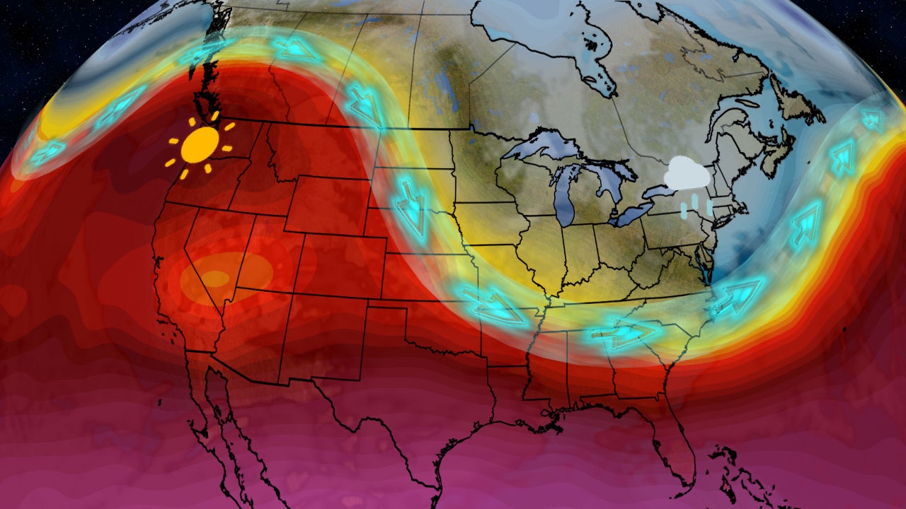
Pattern Change Ahead; What You Can Expect This Weekend
Feel like your weather has been stuck in a rut? Here are the changes ahead.
Pattern Change Ahead; What You Can Expect This Weekend
Please enable JavaScript to continue using this application.