A Delta flight about to leave Orlando, Florida, was disrupted after a fire was spotted in one of the plane’s engines. There were no reported injuries, but the cause of the fire is still unknown.
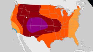
Our latest temperature outlook through August shows an area of persistent heat in the West, while a wetter summer may keep temperatures in check in the East.
Flash floods and tornadoes led to five deaths in Oklahoma as severe storms hit parts of that state as well as Texas and Missouri over the Easter holiday weekend. Tens of thousands lost power at the height of the storms, many roads were flooded and homes and other buildings were damaged.
A 30-year-old snowboarder from Monaco got an icy surprise when he hit the slopes in Niseko, Japan. Watch this video to see the moment he dropped into a cavern filled with water, warning – his language is probably NSFW.
Ladybugs don’t usually creep out most people, but you might change your mind when you see how millions of the tiny beetles have been swarming parts of southern Australia. Watch this video to learn what may be causing the invasion.